
Page 8 - EQTips_Eng
P. 8
Learning
4 Earthquake Design
Earthquake Tip and
Construction
Where are the Seismic Zones in India?
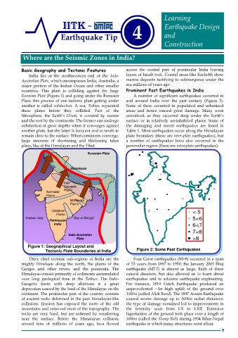
Basic Geography and Tectonic Features across the central part of peninsular India leaving
India lies at the northwestern end of the Indo- layers of basalt rock. Coastal areas like Kachchh show
Australian Plate, which encompasses India, Australia, a marine deposits testifying to submergence under the
major portion of the Indian Ocean and other smaller sea millions of years ago.
countries. This plate is colliding against the huge Prominent Past Earthquakes in India
Eurasian Plate (Figure 1) and going under the Eurasian A number of significant earthquakes occurred in
Plate; this process of one tectonic plate getting under and around India over the past century (Figure 2).
another is called subduction. A sea, Tethys, separated Some of these occurred in populated and urbanized
these plates before they collided. Part of the areas and hence caused great damage. Many went
lithosphere, the Earth’s Crust, is covered by oceans unnoticed, as they occurred deep under the Earth’s
and the rest by the continents. The former can undergo surface or in relatively un-inhabited places. Some of
subduction at great depths when it converges against the damaging and recent earthquakes are listed in
another plate, but the latter is buoyant and so tends to Table 1. Most earthquakes occur along the Himalayan
remain close to the surface. When continents converge, plate boundary (these are inter-plate earthquakes), but
large amounts of shortening and thickening takes a number of earthquakes have also occurred in the
place, like at the Himalayas and the Tibet. peninsular region (these are intra-plate earthquakes).
Eurasian Plate
Himalayas
Indo-
Gangetic
Narmada Plains
Plains
Mahanadi
Plains
Deccan
Godavari < 5
Shield
Plains
Arabian Sea Bay of Bengal 5<6
Peninsular
India 6<7
7<8
Indo-Australian
Plate >8
Figure 1: Geographical Layout and
Tectonic Plate Boundaries at India Figure 2: Some Past Earthquakes
Three chief tectonic sub-regions of India are the Four Great earthquakes (M>8) occurred in a span
mighty Himalayas along the north, the plains of the of 53 years from 1897 to 1950; the January 2001 Bhuj
Ganges and other rivers, and the peninsula. The earthquake (M7.7) is almost as large. Each of these
Himalayas consist primarily of sediments accumulated caused disasters, but also allowed us to learn about
over long geological time in the Tethys. The Indo- earthquakes and to advance earthquake engineering.
Gangetic basin with deep alluvium is a great For instance, 1819 Cutch Earthquake produced an
depression caused by the load of the Himalayas on the unprecedented ~3m high uplift of the ground over
continent. The peninsular part of the country consists 100km (called Allah Bund). The 1897 Assam Earthquake
of ancient rocks deformed in the past Himalayan-like caused severe damage up to 500km radial distances;
collisions. Erosion has exposed the roots of the old the type of damage sustained led to improvements in
mountains and removed most of the topography. The the intensity scale from I-X to I-XII. Extensive
rocks are very hard, but are softened by weathering liquefaction of the ground took place over a length of
near the surface. Before the Himalayan collision, 300km (called the Slump Belt) during 1934 Bihar-Nepal
several tens of millions of years ago, lava flowed earthquake in which many structures went afloat.
7