
Page 47 - Jabalpur_EQ
P. 47
Chapter 2 Selamologlcal Aspects
DHoLPUR Km 50 50 O0 150 Km
ARAVAL 5 d
ARY
K8UNDELKHAND.
HIRAPUR
v
KATANGI VINDHYAN
BASIN
INDORE JABALPUR5200,
MENT, MANDLA INDIA
v235TT
LEGE ND
ALLuvIUM B1JAWAR
DECCAN TRAP
EAARCHAEAN
BMANDER -- SYNCLINAL AXISs
REWA UPPER VINDHYAN FAULT
KAMUR oss PROFILE wITH SHOT POINTS
00003 SEMRI LOWER VINDHYAN AND MAJOR SP NUMBER
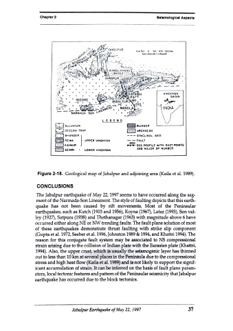
Figure 2-18. Geological map of Jabalpur and adjoining area (Kaila et al. 1989).
CONCLUSIONS
The Jabalpur earthquake of May 22, 1997 seems to have occurred along the seg.
ment of the Narmada-Son Lineament. The style of faulting depicts that this earth-
quake has not been caused by rift movements. Most of the Peninsular
earthquakes, such as Kutch (1903 and 1956), Koyna (1967), Latur (1993), Son val-
ley (1927), Satpura (1938) and Thethanagar (1963) with magnitude above 6 have
occurred either along NE or NW trending faults. The fault plane solution of most
of these earthquakes demonstrate thrust faulting with strike slip component
(Gupta et al. 1972, Seeber et al. 1996, Johnston 1989 & 1994, and Khattri 1994). The
reason for this conjugate fault system may be associated to NS compressional
strain arising due to the collision of Indian plate with the Eurasian plate (Khattri,
1994). Also, the upper crust, which is usually the seismogenic layer has thinned
out to less than 10 km at several places in the Peninsula due to the compressional
stress and high heat flow (Kaila et al. 1989) and is not likely to support the signif-
icant accumulation of strain. It can be inferred on the basis of fault plane param-
eters, local tectonic features and pattern of the Peninsular seismicity that Jabalpur
earthquake has occurred due to the block tectonics.
Jabalpur Earthquake of May 22, 1997 37