
Page 45 - Jabalpur_EQ
P. 45
Chapter 2 Seismolonical Aspects
23.30 TTT TIT
NIbhoratola
Plmria
nnagar Chhatarpr
VIl
Balkhern Unlv. Ghie
Pararla
Luhan VIN OFK, Khamerla
23 20 Amakho
EPICENTER
Gara Renital
Amahlnauta AWrighty Towm
Kogawa Meden Mahel
BIlhard A Bhita
Kolharw Xoshamghat
Gaurayaghat
23.10 Jamtara Barela
Pareswara
Epicenter
MM VII
MM VIl+ Nigr
MM VII Bledand
MM V
23.00 LL LLul
79.8 79.9 0.1 80.2
Longitude (E)
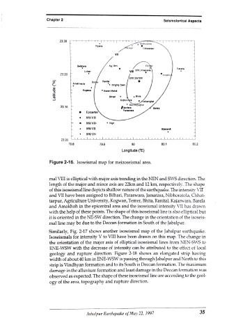
Figure 2-16. Isoseismal map for meizoseismal area.
mal VIII is elliptical with major axis trending in the NEN and SWS direction. The
length of the major and minor axis are 22km and 12 km, respectively. The shape
of this isoseismal line depicts shallow nature of the earthquake. The intensity VIr
and VII have been assigned to Bilhari, Paraswara, Jamatara, Nibhoratola, Chhat-
tarpur, Agriculture University, Kogwan, Temer, Bhita, Ranital, Kajarwara, Barela
and Amakhoh in the epicentral area and the isoseismal intensity VII has drawn
with the help of these points. The shape of this isoseismal line is also elliptical but
it is oriented in the NE-SW direction. The change in the orientation of the isoseis-
mal line may be due to the Deccan formation in South of the Jabalpur.
Similarly, Fig. 2-17 shows another isoseismal map of the Jabalpur earthquake.
Isoseismals for intensity V to VIII have been drawn on this map. The change in
the orientation of the major axis of elliptical isoseismal lines from NEN-SWS to
ENE-WSW with the decrease of intensity can be attributed to the effect of local
geology and rupture direction. Figure 2-18 shows an elongated strip having
width of about 40 km in ENE-WSW is passing through Jabalpur and North to this
strip is Vindhyan formation and to its South is Deccan formation. The maximum
damage in the alluvium formation and least damage in the Deccan formation was
observed as expected. The shape of these isoseismal line are according to the geol-
ogy of the area, topography and rupture direction.
Jabalpur Earthquake of May 22, 1997 35