
Page 100 - Jabalpur_EQ
P. 100
Lifelines
Chapter 6
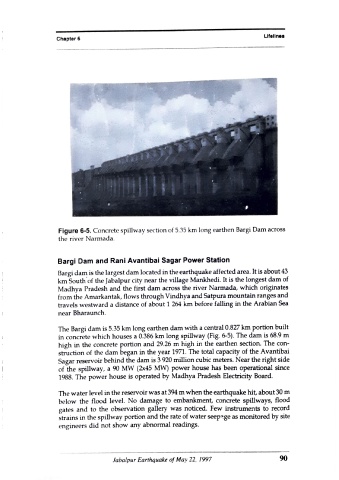
Figure 6-5. Concrete spillway section of 5.35 km long earthen Bargi Dam across
the river Narmada.
Bargi Dam and Rani Avantibai Sagar Power Station
Bargi dam is the largest dam located in the earthquake affected area. It is about 43
km South of the Jabalpur city near the village Mankhedi. It is the longest dam of
Madhya Pradesh and the first dam across the river Narmada, which originates
from the Amarkantak, flows through Vindhya and Satpura mountainranges and
travels westward a distance of about 1 264 km before falling in the Arabian Sea
near Bharaunch.
The Bargi dam is 5.35 km long earthen dam with a central 0.827 km portion built
in concrete which houses a 0.386 km long spillway (Fig. 6-5). The dam is 68.9 m
high in the concrete portion and 29.26 m high in the earthen section. The con-
struction of the dam began in the year 1971. The total capacity of the Avantibai
Sagar reservoir behind the dam is 3 920 million cubic meters. Near the right side
of the spillway, a 90 MW (2x45 MW) power house has been operational since
1988. The power house is operated by Madhya Pradesh Electricity Board.
The water level in the reservoir was at 394 m when the earthquake hit, about 30 m
below the flood level. No damage to embankment, concrete spillways, flood
gates and to the observation gallery was noticed. Few instruments to record
strains in the spillway portion and the rate of water seep-ge as monitored by site
engineers did not show any abnormal readings.
Jabalpur Earthquake of May 22, 1997 90