
Page 29 - Jabalpur_EQ
P. 29
Chapter2 Selsmologlcal Aspects
deformation on large scale. A large low ridge (commonly referred asAllah Bund)
about 24 km wide and 80 km long trending in the East-West lirection was
formed. The land to the North of the Bund was elevated and land to the South of
this was subsided.
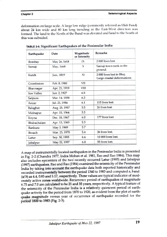
TABLE 2-6. Significant Earthquakes of the Peninsular India
Earthquake Date Magnitude Remarks
or Intensity
Bombay May 26, 1618 IX 2 000 lives lost.
Samaji May, 1668 Samaji town sunk in the
ground.
Kutch Jun., 1819 XI 2 000 lives lost in Bhuj.
Large crustal deformations.
Coimbatore Feb. 8, 1900 VII
Bhavnagar Apr. 21, 1919 VIlI
Son Valley Jun. 2, 1927 6.5
Satpura Mar. 14, 1938 6.3
Anzar Jul. 21, 1956 6.1 115 lives lost.
Balaghat Aug. 25, 1957 5.5 26 lives lost.
Midnapur Apr. 15, 1964 5.5
Koyna Dec. 10, 1967 6.0 177 lives lost.
Bhdrachalam Apr. 13, 1969 5.3
Bankura May 3, 1969 5.7
Broach Mar. 23, 1970 5.4 26 lives lost.
Latur Sep. 30, 1993 6.4 10 000 lives lost.
Jabalpur May 22, 1997 6.0 55 lives lost.
A map of instrumentally located earthquakes in the Peninsular India is presented
in Fig. 2-2 (Chandra 1977, Indra Mohan et al. 1981, Rao and Rao 1984). This map
also includes epicenters of the two' recently occurred Latur (1993) and Jabalpur
(1997) earthquakes. Rao and Rao (1984) examined the seismicity of the Peninsular
India by taking into account the earthquake data both reported historically and
recorded instrumentally between the period 1340 to 1983 and computed a, band
(a/b) as 4.4, 0.85 and 5.17, respectively. These values are typical indicator of mod-
erately active zones worldwide. Recurrence period of earthquakes of magnitude
6.75 and 7.0 are calculated to be 21 and 35 years, respectively. A typical feature of
the seismicity of the Peninsular India is a relatively quiescent period of earth-
quake activity for the period from 1870 to 1920, as evident from the plot of earth-
recorded for the
quake magnitude versus year of occurrence of earthquake
period 1800 to 1983 (Fig. 2-3).
Jabalpur Earthquake of May 22, 1997 19